What is a Right-of-Way?
The streets within the City of Bella Vista are unlike those in other cities due to both the original design in the 1960s and the natural topography of the 45 square miles that make up our city. Did you know the city’s Street Department maintains more than 550 miles of road?
The original platting of the city, in combination with necessary utility easements, creates some confusion as to who owns what part of which property and where the rights-of-way lie.
But first, what is a right-of-way?
- A right-of-way (ROW) is a dedicated area of land intended to provide the legal right of use to the public, which may include streets, crosswalks, sidewalks, trails, water mains, internet/phone cables, sanitary sewers, storm drains, or any other use involving a public or utility company.
Think of it this way: Utilities, such as water lines, must have access to traverse the city for that utility to be provided to residents citywide. If one lot didn’t have any easement or ROW area, a utility may not be able to get through to the other side of it to reach lots beyond.
So – even if you don’t subscribe to the company whose utility lines run along your property (like a cable company) your neighbor and their neighbor might, and therefore they are provided access legally via the ROW.
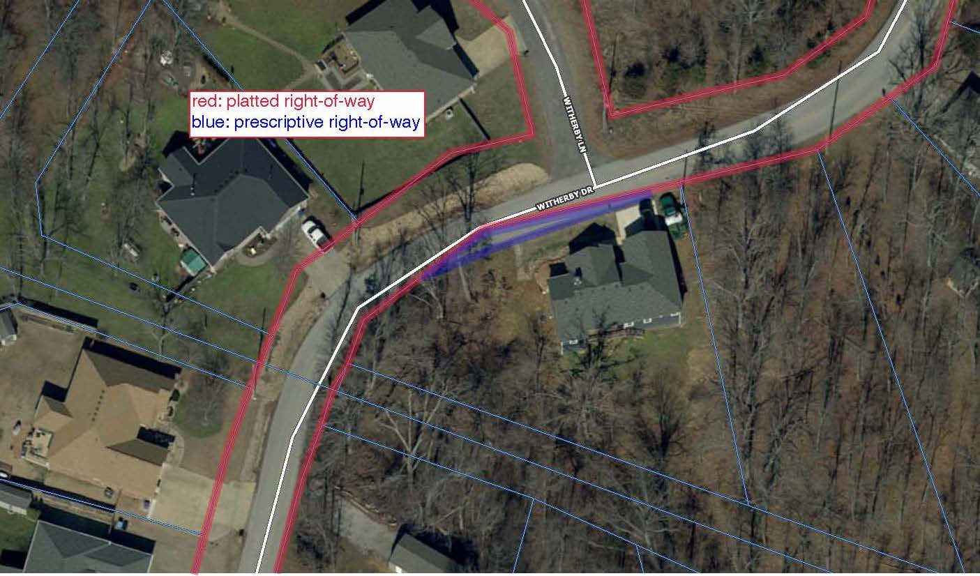
There are two kinds of rights-of-way:
- Dedicated: A dedicated space between lot lines (typically 40 feet in Bella Vista) in which the ROW lies.
- Prescriptive: Area of the roadway that lies outside the platted lot lines and ROW. If the surface of a road lies outside the dedicated ROW, the roadway and a certain number of feet beyond it becomes a prescriptive ROW.
Below is some additional information regarding ROW and utility easements. If you have further questions, call the city’s Planning Division at 479-268-4980 or email planning@bellavistaar.gov.
How big is the ROW area?
A ROW could be anywhere from 40-100’ wide, depending on the type of street on which it lies. The average residential ROW in Bella Vista is 40’ wide, within which the street typically should be centered. Bella Vista is unique in that the streets are not consistently built in the middle of the ROW within the city. Some houses may have 5 feet of ROW while other houses may have 15 feet of ROW in their front yard.
Doesn’t my property line end where it meets the street?
No. Your lot line stops at the edge of the ROW, which extends past the street on either side to allow access for things like street maintenance, sewer lines or other utility lines.
In addition, the majority of lots within Bella Vista contain a 7.5-foot utility and drainage easement along all property lines — including the front property line. However, some lots in Bella Vista have different sized easements such as 20’ or 5’. If you’re not sure what easements are dedicated on your lot, reach out to our city planning division for assistance. These easements typically provide utility companies access should they require it to maintain or improve their infrastructure within the city.
Who owns the ROW?
If it is a city street, then that would be the city’s ROW and overseen by the city. If it is a highway, such as highways 71, 340, or 279, then it is the state’s ROW and overseen by ARDOT.
What is the difference between ROW and utility easement?
- ROW is usually a dedicated access of land that allows for the use of public transportation or public use and necessary utility infrastructure (such as sewer, power, and water lines). ROW areas could include passageways such as streets, alleys, sidewalks, trails, etc. It also normally includes drainage ditches for the street.
- An easement is usually a dedicated access of land that is for a specific use. The most common in Bella Vista are utility and drainage easements which are easements granted for utility companies or drainage improvements.
The utility company messed up the landscaping in my yard while they were working. How are they able to do that?
The city and utility companies are allowed to operate within the ROW without any kind of permission. They are also not required to restore the area once they are finished working. If you have installed landscaping in your yard in the ROW, they are not required to fix that.
Are utility companies required to obtain permits from the city to work within the ROW?
Utility companies do not need a ROW permit, as they have prescribed rights to work within their easements and the ROW. However, if utility work includes boring under a street, then a boring permit from the Street Department may be needed. The Street Department does not oversee this work, however. This permit is intended only to protect the integrity of the street and the drainage in the area and does not guarantee protection of landscaping or other improvements in your yard.
Can I landscape the area of my yard that is adjacent to the street?
Property owners must obtain permission from the city via a ROW use permit prior to placing anything in the city’s ROW. Only a few types of improvements are permissible in the city’s ROW, including flowers, shrubs and grass. Anything in the state ROW may need ARDOT approval and a permit from the city. Very little is permissible within an ARDOT ROW.
Why should I not landscape the ROW area of my yard?
If you choose to landscape the ROW, it must first be approved by Community Development Services via a ROW use permit. If it is a permissible improvement, the property owner must acknowledge the following: improvements made to city-owned rights-of-way will not be repaired, replaced or purchased by the city in any situation where the city, any of its agents, or any public utility operating as a matter of right in the city-owned right-of-way damages or removes improvements for any reason per Section 24-21(4) of the municipal code.
Thus, the property owner is responsible for replacing the landscaping if it is messed up during utility work within the ROW. Placing anything in a utility easement or ROW assumes risk of damage, removal, or replacement at your own cost.
What kind of improvements are allowed and prohibited within the ROW?
Examples of improvements that may be allowed in the ROW with a permit: Decorative landscaping in the form of flowers, shrubs, or grass.
Examples of improvements that are prohibited in the ROW: retaining walls, structures, fill or filling in ditches, rocks/stones, anything with a base larger than 4 square feet, mailboxes within 18 inches of the edge of street, or anything that restricts the flow of stormwater.
Who maintains the culvert beneath my driveway and clears it when it gets clogged?
The property owner. Even though the driveway culvert lies within the city’s ROW, you legally agreed when you purchased your property to maintain that area. Water must be able to flow freely as designed between properties and off the roadway. If the ditches and culverts are clogged, the water will end up somewhere that it wasn’t intended to go, which is typically on a neighboring property. It is important to keep all culverts clear of debris such as sticks, rocks and leaves.
The driveway culvert on my neighbor’s property is clogged and water has flooded my property. What can I do about this?
This is a civil matter between neighbors. We urge residents to consult a professional for this type of water mitigation.
I want to fill the ditch along my property at the roadway with rock, so it’s easier for me to maintain. Is that allowed?
No. Streets are designed so that water runs off in a particular way, and drainage ditches and culverts are designed to carry that water away in a particular way. When you alter the design of the drainage system, you change the way the water moves away from an area. This is not allowed.
I would like to extend my driveway culvert to carry water further away from my lot. Is that allowed?
No. Property owners are responsible for maintaining culverts that were designed to properly move stormwater. Changing this design or extending a culvert will negatively affect the drainage in the area and will make regular culvert maintenance – which is the property owner’s responsibility – difficult or even impossible.
Who maintains the driveway apron (the strip of asphalt that connects my driveway to the street)?
The property owner is responsible for maintaining the driveway apron.
Can I add a second driveway to my residence?
Any access drive that is not a part of a residential new build permit must obtain a driveway permit from Community Development Services.
How can I find my exact lot lines, including ROW?
The best way to determine your exact lot lines and how much ROW is in your front yard is a survey from an Arkansas-licensed surveyor. However, Benton County GIS may offer an approximate estimate via their free measuring tool: https://gis.bentoncountyar.gov/basemap/index.html
I have noticed flagging in the ROW surrounding my property. How do I know what those flags are for?
811 Call Before You Dig requires that utility lines be marked prior to digging. Each utility company marks their lines in a designated color. These colors may be classified as:
- Blue — potable water
- Green — sewer/drain lines
- Orange — communication lines
- Pink — temporary survey markers
- Purple — reclaimed water/irrigation lines
- Red — electric lines/cables
- White — proposed excavation
- Yellow — gas/oil/petroleum lines